
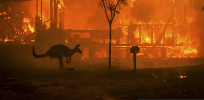
Red alert in Australia : where will the next major bushfires strike ?
Australian authorities and climate scientists use precise models to identify areas of maximum risk. As of December 2025, Australia is in the heart of its summer season, and several regions are under close observation.
Here are the most vulnerable areas for the remainder of the 2025-2026 season, based on reports from the AFAC (Australasian Fire and Emergency Service Authorities Council):
Western Australia (WA): The current hotspot
 This is currently the most at-risk region. The combination of a very dry winter and early heatwaves has made the vegetation extremely flammable.
Target areas: The southwest of the state (around Perth) and the Margaret River region.
The risk: Dense eucalyptus forests with an accumulation of unburned, unburned « combustible » material (leaves and dead wood) on the ground.
Queensland and Northern New South Wales
 Following the heavy rainfall of previous years associated with La Niña, vegetation grew dramatically. With the return of drier conditions in 2025, this grass dried out, becoming ideal fuel.
 Target areas: The Darling Downs and the border regions between Queensland and New South Wales.
The risk: Fast-spreading grass fires that are easily amplified by the wind, threatening agricultural and rural areas.
Victoria and South Australia (SA)
These regions are often the last to enter the fire season (January-February), but they are the most prone to catastrophic bushfires.
Target areas: The Gippsland (Victoria) and the hills around Adelaide.
The risk: Extreme temperatures exceeding 40°C coupled with strong winds from the central desert.
 Why are these areas threatened this year?
Fuel accumulation: Previous rainy years have fostered massive vegetation growth. Now that this biomass is dry, it acts like tinder.
The Indian Ocean Dipole (IOD): By 2025, variations in water temperature will influence winds and reduce humidity over the Australian continent, exacerbating drought.
Climate change: The fire season now starts earlier and ends later, with « catastrophic fire risk » days more frequent than twenty years ago.
How to stay informed in real time?
If you have loved ones in the area or are planning a trip, here are the essential tools:
Fires Near Me (App): The official app for tracking fire outbreaks in real time.
BOM (Bureau of Meteorology): For extreme heat and landslide alerts.
ABC Emergency: The national radio station broadcasting evacuation instructions.

On the same subject

Why is it so confusing ?
The history of ancient Egypt is exceptionally long, spanning over 3,000 years. To navigate...

Already 300,000 after Hurricane Melissa
The Jamaica Tourist Board has officially announced that the island has surpassed the symbolic...

Why North American tourists overwhelmingly prefer trains to visit Europe
As the end of 2025 approaches, Rail Europe has just unveiled booking statistics revealing...

